Steer analysis offers data-driven, transit-oriented view of green and grey belt potential
Steer has launched an online story map showcasing the potential for sustainable, well-connected green and grey belt development.

Update – 12th December 2024:
As the UK government provides further details on its approach to delivering 1.5 million homes, our Planning Reform Story Map helps demonstrate some of the challenges and opportunities local authorities will have to consider. These are:
- Prioritising brownfield – a default 'yes' to development
- A 'common sense' approach to greenbelt - reviewing greenbelt boundaries to help meet housing targets that will identify and prioritise lower quality ‘grey belt’ land.
- Identification of a set of 'golden rules', ensuing development provides the necessary infrastructure for local communities, such as access to key services (GP surgeries, schools) and public transport.
With the government providing additional funding to local authorities to help speed up the planning decision making and support technical studies and site assessments, analysis and tools underpinned by spatial data can play an important role in helping local authorities grapple with their new housing targets.
Original article, posted 4th December 2024:
Steer has launched a new online story map offering a unique take on the potential for well-connected, sustainable green and grey belt development.
Experts at Steer have compiled and analysed data a range of open-source planning data to understand what and where the grey belt is, and how much development potential there is around railway stations.
The findings seem to echo the concerns being raised by local councils that only a minority percentage of land has the necessary transport infrastructure needed to contribute to sustainable development.
What is the grey belt?
The grey belt is defined as "land in the Green Belt comprising Previously Developed Land and any other parcels and/or areas of Green Belt land that make a limited contribution to the five Green Belt purposes" and has been listed by the UK Government as prime location for some of the 1.5 million homes it plans to build by the end of this parliament.
The Government is pursuing a Brownfield-first policy but has identified the grey belt as the next suitable category of land suitable for building. While it is tempting to see the grey belt merely as low value countryside, such areas do carry attributes that make them prime areas for sustainable, well-connected developments.
Grey belt land is often on the outskirts of towns and cities, meaning centres would be accessible for homes built there, providing a catalyst for growth in the ‘productivity engines’ of the economy. By building homes around existing transport infrastructure, we can support the sustainability of future developments.
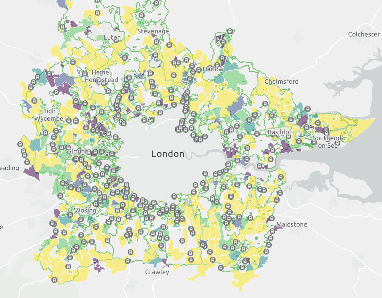
Which locations have the highest proportion of grey belt land?
Earlier in the year, Steer launched the first edition of its Planning Reform Story Map (PRSM), a tool that helped everyone from local authorities to property developers understand upcoming changes to the National Planning Policy Framework (NPPF).
This next phase of PRSM outlines which areas and local authorities host the most potential grey belt land suitable for development as per the NPPF definition. According to our analysis of the data, the grey belt could host 10-15% of the Government’s building target of 1.5 million over the next five years.
Warwick, Buckinghamshire, North Warwickshire, Thurrock, Rushcliffe, Solihull, Hillingdon, Three Rivers, Doncaster and Lichfield have the most grey belt potential, according to the data. However, these results provide merely a starting point for exploring development, as the practical implications of building on this land remain to be seen on the basis of a) technical feasibility (e.g. the need for site remediation or complex access); b) commercial viability and desirability; c) land ownership; and d) potential cultural and community importance of ‘vacant’ sites.
In a consultation exercise carried out by the Ministry of Housing, Communities and Local Government (MHCLG), many local councils have raised concerns that the algorithm used to calculate housing targets for each area has not taken into account strains on local infrastructure, amongst other factors.
A report released by thinktank Centre for Cities investigating how likely it is that the Government will meet its target has proposed the “release of some green belt land for development, especially in walking distance of railway stations with connections to England’s most expensive cities.”
The move towards transit-oriented development - how much housing can be developed around railway stations?
Steer has also looked at the density of potential grey belt land close to railway stations near the green belt, of which there are 679 in total. Dismissing locations that have higher levels of protection (e.g. SSSIs or ancient woodland) or are unsuitable (e.g. higher flood risk, Grade 1 agricultural land, already developed), this number falls to 48.
We have then examined which stations have the highest areas of vacant land within unprotected green belt land to try to quantify the number of houses that could be delivered around a station. Using this analysis, we’ve calculated that land around railway stations in the green belt could contribute around 50,000 houses (just 3.5% of the Government’s housing target).
“As local planning authorities with green belt land review the development potential and suitability of sites as part of their Housing and Economic Land Availability Assessment, we expect these to evidence clear potential in grey belt development, but not at the level that is needed to deliver 1.5 million homes in the next five years,” says Steven Bishop, Director at Steer.
“Significant challenges exist, and even vacant sites have complex issues of viability, sites of cultural sensitivity and importance. The grey belt carries possibility but doesn’t provide answers on its own.”
“Without a clear definition on the grey belt, using data or an algorithm alone to define potential locations is challenging and opens up the risk of legal challenge if different interpretations are used by developers and local authorities,” adds Oliver Russell, Steer Associate.
Request access to Steer’s Planning Reform Story Map by clicking here.